Logandale Trails Project
Welcome and Project Introduction
Welcome to the virtual public meeting website for the Bureau of Land Management Las Vegas Field Office Logandale Trails Resource Management Plan Amendment, Environmental Assessment, Recreation Area Management Plan and Travel Management Plan (Logandale Trails Project).
Background
Welcome Sign at Logandale Trails
The Logandale Trails planning area is managed by the BLM Southern Nevada District, Las Vegas Field Office. The planning area is situated in a confluence of three unique geographic zones: the Colorado Plateau, the Mojave Desert, and the Great Basin. The lands adjacent or within Logandale Trails are managed by other federal agencies, the State of Nevada, local government entities, as well as private property will not be addressed in the Logandale Trails Project.
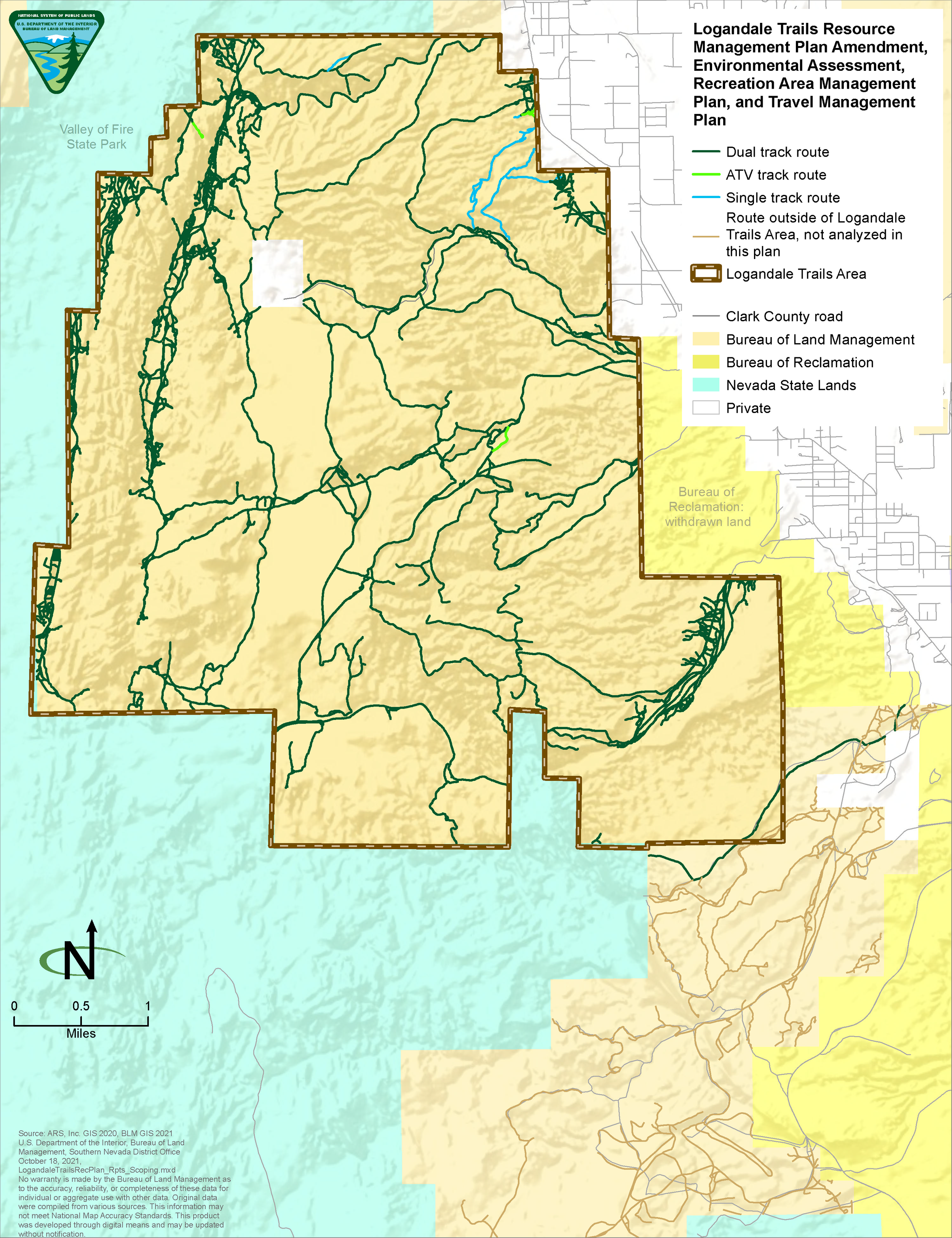
The Logandale Trails Project planning area is approximately 15,300 acres of BLM managed public lands (see map below). The BLM has revised the previous acreage from 15,019 acres to 15,300 acres due to an error in calculations found in our GIS data while the draft EA and planning documents were being drafted.
The Logandale Trails area provides numerous recreation opportunities, including off-highway vehicle use, equestrian use, picnicking, hiking, mountain biking, camping, commercial tour businesses and sight-seeing. The area is rich in natural resources, such as habitat to the threatened desert tortoise, as well as special status plant and wildlife species. It also contains sensitive archaeological resources and unique land features such as sand dunes.
Planning Process
Currently in the Las Vegas Resource Management Plan, the Logandale Trails planning area is designated as an Extensive Recreation Management Area. As part of this process, the BLM is proposing to amend the Las Vegas Resource Management Plan to designate the Logandale Trails area as a Special Recreation Management Area. The priority management consideration in the Logandale Trail planning area is recreation and particularly, motorized recreation.
In addition to designating Logandale Trails as a Special Recreation Management Area, the Las Vegas Field Office has developed a Recreation Area Management Plan. The Recreation Area Management Plan will serve as the guiding document for managing recreation use in the area, including but not limited to, off-highway vehicle use, camping, hiking, target shooting and Special Recreation Permits (organized group, commercial and special events). The Recreation Area Management Plan will include a Travel Management Plan.
The Travel Management Plan identifies existing routes and trails in the Logandale Trails area and determines the appropriate management for those routes. Some of these routes will be designated as open to the public, routes for administrative use only, and routes to be closed and rehabilitated. The Travel Management Plan will also identify what types of travel (motorized, mechanized, equestrian, pedestrian) will be allowed on each route. The Travel Management Plan may designate new routes to help meet the goals and objectives of the Recreation Area Management Plan and Las Vegas Resource Management Plan. Because the project is being completed at the federal level, the BLM will comply with The National Environmental Policy Act, through development of the Environmental Assessment that will evaluate the environmental and related social and economic effects of the proposed Logandale Trails Project.
For additional information please use our interactive map on Station 6: Alternatives to navigate the options being considered.
Overview Map of Planning Area
Select Next Station to review the NEPA and Public Involvement details or choose from one of the stations below to go to a specific topic. Stations 2, 3, 4, and 5, listed below, provide additional detail regarding each of the plans.
For more information on the Logandale Trails Project or to be added to the mailing list, please contact Kenneth Kendrick (702-515-5073) or Colleen Cepero Rios (702-515-5395) or email BLM_NV_LVFO_Logandale_RAMP@blm.gov


